Surveying is the preliminary and primary step to kickstart any kind of project properly.
There are different types of surveying methods available to discover the earth’s surface. The right surveying method is chosen depending on the size and existence of hindrances on the land.
The plane table surveying is one of the conventional surveying methods, which is used to measure small scale land. If the land that you are surveying is plane and absence of obstacles also influenced by the magnetic field, then the plane table survey is preferable.
What is the plane table surveying?
In surveying, when the earth’s surface is assumed to be a plane, and the curvature of the earth is omitted, it is called Plane Surveying.
The plane table surveying is a simple and easy method where the plotting and field observations are done simultaneously. The map of the land prepared while doing the fieldwork.
Moreover, plane table surveying could help to measure the land area where the compass survey method may fail due to the magnetic field.
Principle of plane table survey
Parallelism is the principle of a plane table survey. Two or more stations will be plotted to measure the land, and the drawn line passes through the station point.
- The line connecting any two points is considered a straight line (AB), and the angle between any two lines is viewed as the plane’s angle (θ). Any triangle made by the plane survey is also called a plane triangle.
- The Plane surveying method is suitable for surveying up to 250 km2 area. It is used in the construction of dams, bridges & road work.
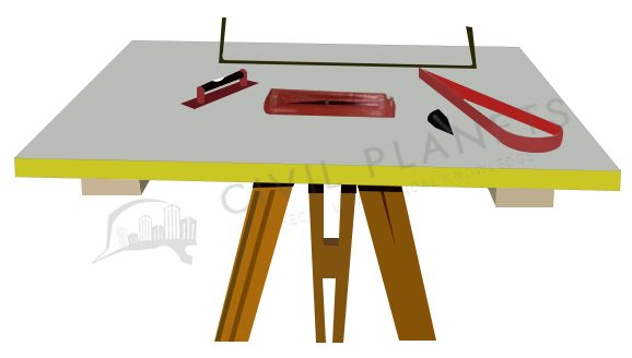
Equipment and Accessories used for plane table survey
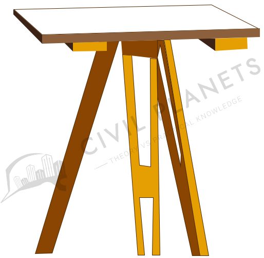
- Plane Table – Wooden board size of 750mm x 600mm
- Simple Alidade and Telescopic Alidade – Optical view sight which helps to plot.
- Plumb bob – Used to make a vertical reference line
- Compass – Helps to draw the line measurement on the paper.
- Tripod – Wooden or Aluminium material which helps to rest the Wooden board.
- Ranging rod – Used to establish the points.
- Spirit level – To check the level of the table.
- Chain – Used to measure the distance between the plotting points.
- Drawing sheet for plotting
- Paper clip
- Other accessories for drawing
We already discussed the plane table surveying instruments in detail.
Setting up the plane table
Three simple, easy steps can do the setup of a plane table survey instrument.
- Levelling – Arranging and setting up the plane table over the tripod stand at comfortable, workable height, and checking the level with the help of the spirit level is known as levelling.
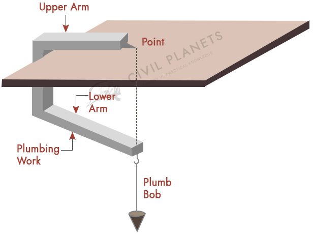
- Centering – Centering is the process where the plane station should be fixed accurately on the centre point of the plotted mark by the help of plumb bob.
- Orientation – Orientation is necessary when we fix more than two stations. It helps to keep the board parallel to the previous stations. So the line of the map can be drawn on the drawing sheet parallel to other stations.
Methods of plane tabling
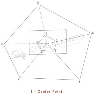
- Method of radiation – The whole to the part method is used in this method. Only one station will be fixed (most probably at the centre) which covers the whole area by drawing radial lines from the station.
In the picture below, I is the centre point of the station. A, B, C, D, E points are fixed by using the alidade and the distance of those points measured by the chain link.
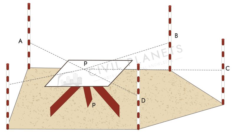
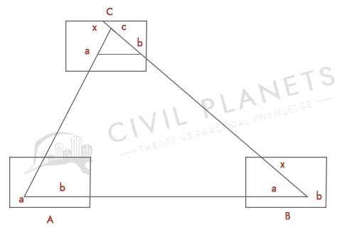
- Method of Intersection – This method is used when the radiation method is not possible due to obstacles such as mountains or rivers. From the picture, suppose the P is the point which has to be measured, but its plotting point is across the river, then it can be done by an intersecting line drawn from two stations (A, B)
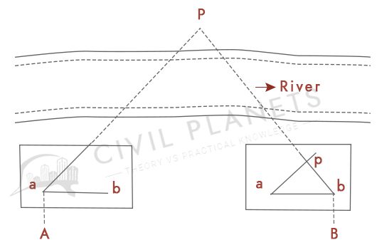
A and B are fixed to point out the P. Line will be drawn from both stations and the intersecting point is noted as P.
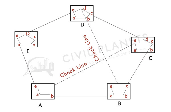
- Method of Traversing – The traverse survey contains a series of connected lines. In this survey, the length and direction of the lines will be measured by the tape. From the below picture, the length of AB is measured, and again BA is measured, then the average of the two values is drawn on the sheet, and the same is applicable for all stations.
To reduce the errors, few check lines are plotted to get the accurate land map. We can get the length of the check line by using simple triangle formulas.
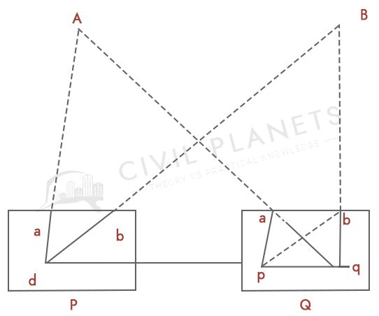
- Method of Resection – When new stations need to be established the resection method will be performed. When the location of the plane table is unknown, it will be calculated from the known points of the plot. It is more like an orientation. The following two methods help to establish the station point.
-
-
-
-
-
- Three-point problem method
- Two-point problem method
-
-
-
-
-
Three-Point Problem Method
In the three-point method, three known points are selected which have already plotted on the map—the new station point obtained by bisecting the three points by the following method.
- Tracing method – Using trace paper
- Lehmann method – Using the triangle of errors method
- Analytical methods – Mathematical method using length and angle
- Graphical method – Known measurements will be plotted on the graph to establish the unknown point.
Tracing Method
This is more like drawing a demanding pic using tracing paper. In this method, the plane table (aka station) will be set up at one point where three known points are visible.
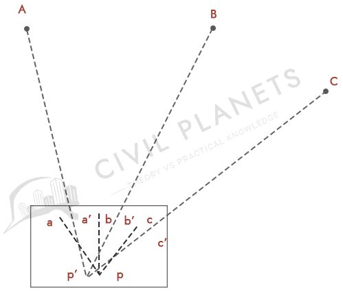
First plot the radiating lines (sighting three known points) on trace paper by sighting the three points. Once finished, place the tracing paper on the drawing and try to match the radiating lines passing through the corresponding points previously plotted. Finally, the position of the station will be established.
Two Point Problem Method
This is also more like a three points method. The only difference is instead of three known points, here we use two known points. There are two cases.
- When two known points can be drawn on the plane table (by intersecting)
- When two known points could not be drawn on the plane table (does not intersect)
Important Points
- Ensure the plane table has been levelled and plotted correctly for more accurate measurement recording. It should be easy to rotate at the time of orientation.
- The alidade and plane table should be levelled and appropriately pivoted.
- Avoid local attraction while marking the magnetic north on the paper.
- Ensure the entire area and plot points can be covered on the paper by selecting a proper scale (map scale)
- The lines connecting survey stations and the objects should be drawn in a dashed line.
Errors in Plane Table Surveying
Like on every surveying, the plane table will be impacted by the following errors. So try to avoid or minimize the errors.
- Instrumental Errors – Defects in instruments such as alidade, uneven plane table etc.
- Errors in manipulation and sighting – Defects in Setting, Levelling & orientation errors
- Errors in plotting – Errors in establishing the radiating lines and known points. The defective scale of a map
Advantages of Plane Table Surveying
- A rapid method of surveying
- A suitable method to measure small scale lands
- Human errors will be eliminated since most of the work (plotting & surveying)will be done simultaneously on the field.
- No high-cost equipment required.
- A suitable method to work in magnetic fluctuation areas
- Since tract is in view any irregular objects and contours such as trees, ponds will be represented accurately.
- No skilled personnel required to plot the map
- Easy to cross-check the measurements
Disadvantages of Plane Table Surveying
- Setting the plane table and orientation is a time-consuming process.
- Not suitable for rough weather.
- It can be done only in the day time.
- Not suitable for larger areas.
- Less accurate comparing other surveying methods
- Not suitable in areas where viewing points will be affected by dense trees and forests.
- Whole surveying instruments are heavy and awkward to carry.
Read More
- Instruments used in Plane Table Surveying