Different types of surveying methods have been used in construction based on the scope of the work. The chain surveying is the conventional method suitable for small scale uneven surface land.
The area will be divided into several triangle pieces.
The length of each triangle side should be measured, and the angle of the triangle is not required for calculation.
Then the area will be calculated from the triangle using the triangulation method.
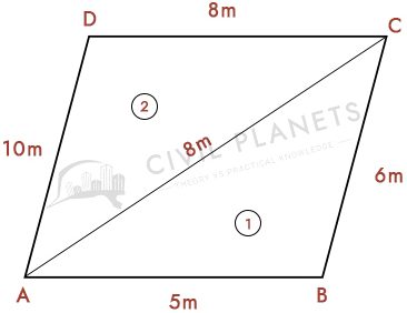
Example Chain Surveying Calculation
From the above picture, the area of the surveyed land will be calculated by the following formula.
Area = √s(s-a)(s-b)(s-c)
The total area of the land is an addition of the two triangles.
Area1 = √s(s-a)(s-b)(s-c)
S = (a+b+c)/2 = 9.5
Area1 = 14.98 Sqm
Area2 = √s(s-a)(s-b)(s-c)
S = (a+b+c)/2 = 13
Area2 = 31.22 Sqm
The total area of the land is 46.2 Sqm.
Parts of Chains used in Surveying
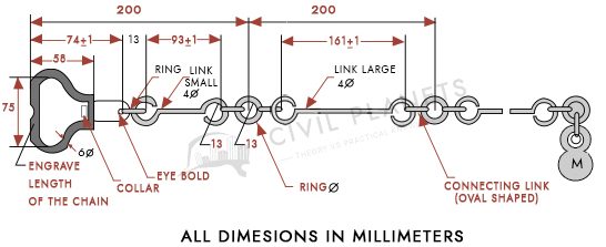
The picture of the chain which is used in the survey is given below. The usual length of the chain is 10m to 30m, which consists of many components to make the survey easy.
The chain consists of 100 to 150 links. The links are made by galvanized steel with 4mm diameter.
Brass handle provided at both ends of the chain.
Tallies have been provided at every 10th link to measure the length easily.
The shape of the tallies has been differing according to the chain length.
The length of the chain is mentioned at the end of the handle.
Types of Chain in Surveying
The following are the types of chain used in surveying.
Metric chain
Steel band or Band chain
Gunter’s chain or surveyor’s chain
Engineer’s chain
Revenue chain
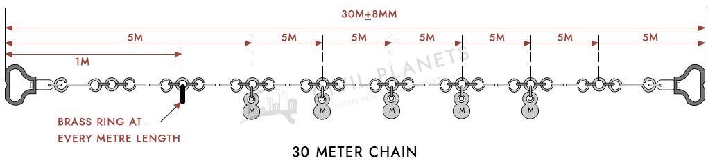
Metric Chain
The length, size & other aspects of the metric chain manufactured as per IS code 1492. The metric chains are made in the length of 5m, 10m, 20m & 30m. Mostly the 30m length chain is used for the chain surveying.
The tallies provision in the chain depends upon the length of the chain. The shape & size of the chain differs from taking measurements quickly.
The length of the brass handles 75mm to hold the chain.
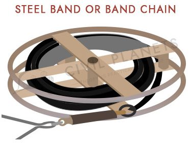
Steel Band or Band Chain
The length of the steel band is about 20m to 30m. The brass swivel handle has been provided at each end of the chain. The width of the steel band is 16mm.
A brass stud has been placed at every 0.2m of the steel band which is used to measure length quickly.
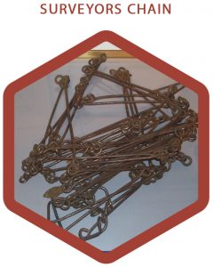
Gunter’s Chain or Surveyor’s Chain
The length of the surveyor chain is 66 ft which consists of 100 links. The length of each link is 0.66ft. Mostly it is used to find the distance between the public land sector in the US.
10 Square Gunter Chain – 1 Acre
100 Square Gunter Chain – 1 hectare
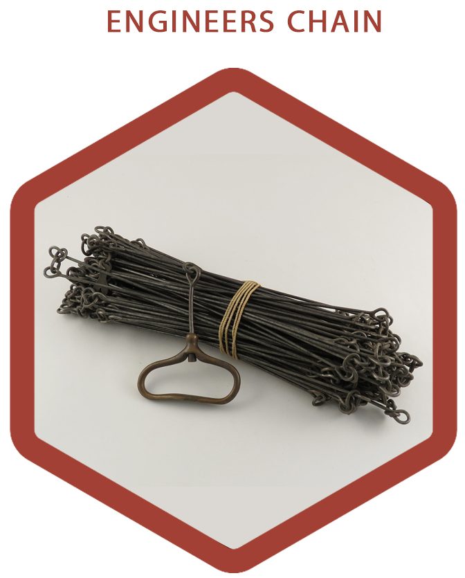
Engineer’s Chain
The length of the Engineer chain is about 100 ft which consists of 100 links. Each link length is 1 ft and every 10 feet a brass ring is provided to measure the length.
Revenue Chain
The length of the revenue chain is 33 ft & having 16 links, and the length of each link is 2.062 ft. The revenue chain is used in the revenue department used to measure the extent of the land into acres or hectares.
Technical Terms
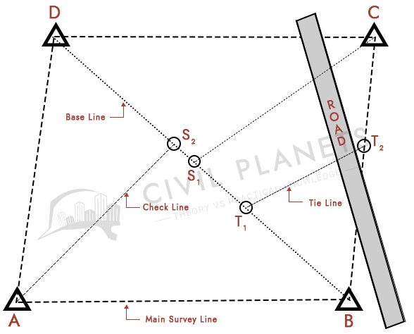
Main Station – The mainline which covers the whole area and points fixed in these lines are called main stations. A, B, C, D are the main station.
Substation – The station which was plotted in the land other than the main station is called substation. The S1, S2 & S3 are the substations.
Tie Station – The station line which connects the main & substation is called tie station. T1 & T2 are the tie stations.
Mainline – The line which connects the main station around the boundary is called the mainline.
Baseline – The longest line of the survey and significant, which gives a frame for the survey is called the baseline. The baseline should be measured carefully without any error.
Check Line – The check line is used to check the accuracy of the divided triangle. The connecting line of the apex of the triangle and some station points is called the check line.
Tie Line – The tie line connecting the tie station points. It helps to take the inner measurement, which is far from the baseline.
Testing and Adjustment of Chain
The accuracy of measurements within the range +/- 2mm. The tolerance of the chain length will be in the limit, as mentioned below.
5m Chain – +/- 3mm
10m Chain – +/- 3mm
20m Chain – +/- 5mm
30m Chain – +/- 8mm
We may face some issues while handling the chain. So check the parts of the chain regularly.
If you found damages in the chain, then replace the specific component. Ensure the chain is free from mud or other dust particles which is obstructing the length of the chain.
Errors in Chain Surveying
Personal Errors
Compensating errors
Cumulative errors.
1. Personal Errors
It is called human error. In any work, there is a possibility of 5% human error. So take reading carefully & avoid such things happening in surveying.
2. Compensating Errors
Sometimes you may get high value or low-value reading when surveying a larger area.
Those errors happen because of
The incorrect marking of the tallies or end of the chain.
The chain was not properly held in a straight direction.
3. Cumulative Errors
The addition of all errors is called cumulative error. To resolve the error at the beginning stage of surveying else the total errors collective after error.
The ranging rod is not fixed at the right place.
The chain was not held straight.
Sagging of the chain.
Improper stretching of the chain.
The surveying is the preliminary & essential stage of a project. So properly take surveying without any error.
Advantages and Disadvantages of Chains in Surveying
SI
Advantages
Disadvantages
1
Suitable for small land.
Not suitable large scale land.
2
The parts of the chain are easily replaceable.
Difficulties may be faced while obstruction in the land while doing the survey.
3
Less workmanship. Booker, leader and follower are enough to take the survey.
Time delay.
4
The calculation which involves measuring the area is simple.


3 Comments
I like your work in surveying. Do you have this in power point presentation. If yes, can I use this as reference to my Class. Thanks
Very nice teaching, and makes it easy to learn. These are excellent instructions for beginners and professionals.
Very Easy Explanation
I understand topics easily