
We already discussed the objective & principles of surveying.
Surveying is like a travel plan for a trip. It guides you through the project. It helps to dictate the sequences and route map for the entire project. Here we are going to discuss the types of surveying.
Methods of Surveying
The primary methods of surveying are
- Plane Surveying
- Geodetic Surveying
Plane Surveying
We knew that the earth is in sphere shape.
In surveying, when the earth’s surface is assumed to be a plane, and the curvature of the earth is omitted, it is called Plane Surveying.
- The line connecting any two points is considered a straight line, and the angle between any two lines is viewed as the plane’s angle. Any triangle made by the plane survey is also called a plane triangle.
- The Plane surveying method is suitable for surveying up to 250 km2 area. The plane surveying methods are used in the construction of dams, bridges & road work.
Geodetic Surveying
The earth’s surface not considered as plane and curvature of the planet also taken into account for measurement is called Geodetic Surveying.
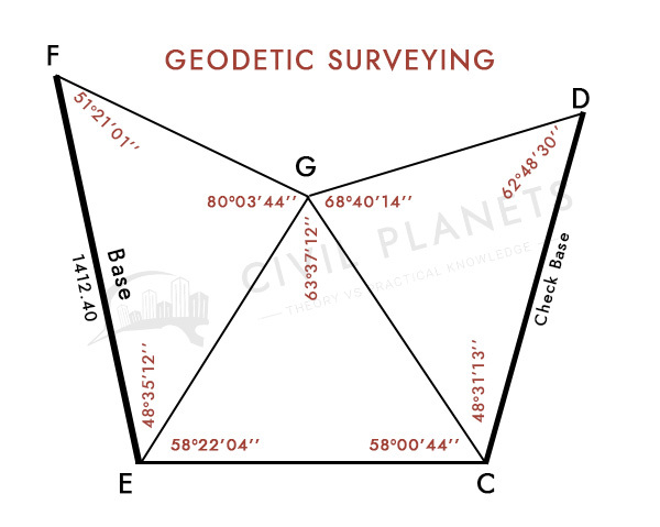
- The government department of surveying will carry the Geodetic Surveying under the direction of survey general.
- The geodetic survey method gives high accuracy compared to the plane survey method because the earth’s curvature is also measured.
- The line connecting any two points is considered as an arc, so the angle between the two arcs is considered as a spherical angle.
- Precious knowledge has been required in trigonometry to carry this method of surveying. The geodetic surveying covers the area above 250 Km2.
Difference between the Plane and Geodetic Surveying
| Plane Surveying | Geodetic Surveying |
| Earth is considered as a plane. | Earth is considered as a sphere(Curved Surface). |
| The line joining 2 points will be considered as a straight line. | The line joining 2 points will be considered as a curved line. |
| The triangle formed by 3 points will be considered as a plane triangle. | The triangle formed by 3 points will be considered as a spherical triangle. |
| Suitable for an area of less than 250 Km2. | Suitable for the area more than 250 km2. |
Classification of Surveying
The classification of surveying is dependent on the nature of the field, objective & instruments.
Based on Nature of the Field
- Land Survey – The land surveying is the investigation of the terrain like the river, falls, or maybe a town, village.
- Marine Survey – The marine survey involves discovering the sea level, mean sea level, and planning, preparing of harbor construction.
- Astronomical Survey – To find out the fixed point of any location of the earth’s surface. This survey also deals with knowing the position or distance of the planet like sun, stars, etc.,
Based on the Objective
- Engineering Survey – The engineering survey is used to determine the data used in engineering works in buildings, bridges, and roads.
- Defense Survey – Preparation of the map for military areas.
- Mine Survey – This survey shall be carried out to explore mineral wealth below the earth’s surface.
- Geological survey – The geological survey is carried out by the government to develop the map of the natural resources of a country.
- Archaeological survey – To prepare a map of the ancient area location of a country.
Based on the Survey Method
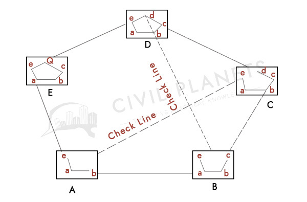
- Triangulation Survey – The basic of the triangulation survey is trigonometry, mostly it is carried out in the hills area. By the data of the baseline & angle of other points, we can determine the length of the other sides. The execution of the triangulation survey is a little critical, but the result of the study gives high accuracy.
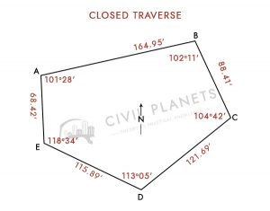
- Traverse Survey – The traverse survey contains a series of connected lines. In this survey, the length and direction of the lines have been measured by the tape. The angle between the lines is also noted for calculating the survey area. The traverse survey has been further classified as closed traverse and open traverse, as shown in the pictures below.
|
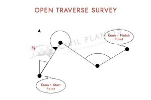 |
Based on the Surveying Instruments
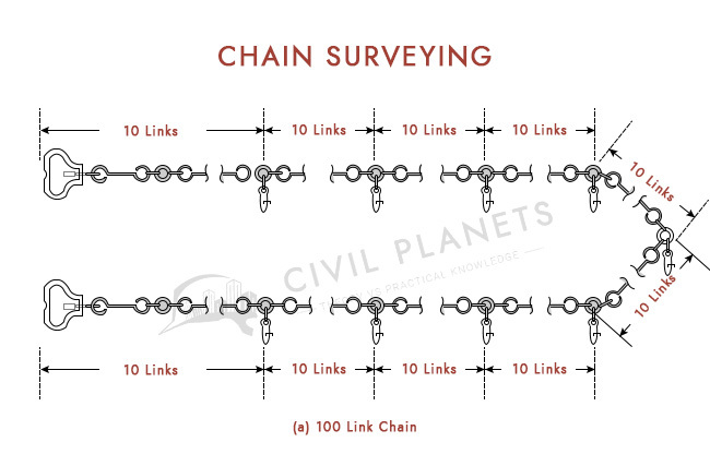
The chain survey is the conventional method of surveying, which is used to survey small land. The survey areas are divided into a number triangle and can be calculated. The chain of length is around 20m to 30m. This survey method has been suitable for minor uneven surface land.
Compass Surveying
The compass survey principles are traversed.
The survey points are connected as a series of lines and 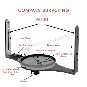 measured by the compass instrument’s magnetic bearing. The angle between the lines is measured, and the chain measures the length of the lines.
Two different types of instruments are used in compass surveying.
- Prismatic Compass
- Surveyor Compass
We have discussed this in detail on Compass Surveying.
The plane table survey is suitable where the area is not larger & does not require high accuracy.
The fieldwork points are simultaneously plotted on the drawing, which is placed over the plane table. The plotted points are correlative with each other.
Theodolite Surveying
Theodolite surveying used where high accuracy of results required.
The telescope, which is mounted on the theodolite instrument, can rotate 360 degrees in both horizontal & vertical directions. So the measurement can be taken both horizontally & vertically. The vertical & horizontal angle can calculate the length of the survey points.
Theodolite Surveying is used in all types of construction roads, bridges, dam & pipeline projects.
Tacheometric Surveying
The tachymetric survey is used mainly in contour surveying.
The measurement of the distance can be taken in both horizontal & vertical directions. The stadia distance and reduced level will be calculated for the distance of the points.
Dumpy Level or Auto Level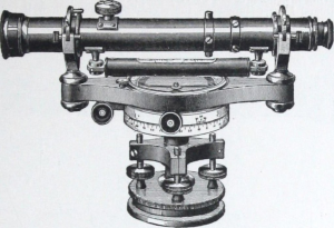
The dumpy level or auto level instrument survey is mostly used where the earth’s surface is uneven. The measurement can be measured in a 360-degree horizontal direction.
The reduced level points are calculated by the height of the collimation or by the rise and fall method.
Aerial Surveying
To discover the overview of an area, aerial surveying is carried out from the aeroplane or helicopter. The photographs will be taken from an elevated position to identify the object clearly from the top angle.
Total Station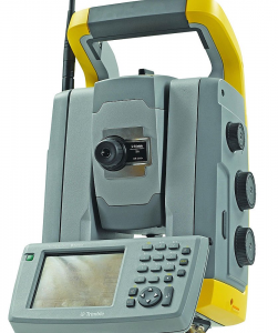
The technology improvement of theodolite is a total station.
The total station is an electronic instrument that is mostly preferred for surveying at present. The measurement of distances & angles are recorded in the device & can quickly get the result through a computer.
Hope you learned about the types of surveying.
Happy Learning 🙂


1 Comment
Thank you, Bala <3